Monday, July 30, 2007

Billy Barker

(Image from BC Archives A-01144)
Ever since the visit to Barkerville, I have been wanting to find out more about Billy Barker who found Gold at Barkerville.

Billy Barker was born in Cornwall England and came to Canada in 1858. He was a Canal operator in England and with the arrival of trains, the water travel was becoming less popular. Barker went to US first, hoping to strike gold at the California Gold rush, he then moved to Canada.

In 1861, a party led by William "Dutch Bill", found gold in a stream up the Fraser river and they named it Williams Creek in Dutch Bill's honor.
Most of the mining activity was confined to the portion of the creek above the canyon where gold was found at a shallow depth. Billy Barker was planning to stake the area around Williams creek, but all the available land was staked around the creek. He decided to stake the area where Barkerville is right now, a decision that was laughed at by everyone. Because that area was downstream beneath the canyon. Everyone knew there wouldn't be any gold there. He was the instant fool of Barkerville.

Billy Barker continued to dig in search of gold and he found none. He decided to dig one last time before calling it quits. He dug 40 feet, 50, feet and at 52 feet he hit pay dirt. A single pan yielded gold that was worth $5 and withing 48 hours they managed to get 1700gm of gold(today's equivalent of 8 million dollar worth of gold!)

There has been many stories about Billy Barker. One says he used to sing when he entered a saloon

"I'm English Bill,

Never worked and never will,

Get away girls,

Or I'll tousle your curls!"


Within days Barkerville was the town, the population swelled from 10 to 4000 in a short span. Barkerville suddenly became famous.


Billy Barker remarried and the legend is that his wife enjoyed spending the money! Billy Barker never striked gold again and when the money ran out, so did the wife.

Billy Barker died as a pauper in an old age home in Victoria. He died on July 11, 1896
BC Archives images of BarkerVille

Wednesday, July 25, 2007

Day 1: Barkerville

If you are ever planning to take a trip down Alaska highway, there is one book you must have. MILEPOST. For a directionally challenged person like me, milepost was a saviour. I knew where the camp sites were, where the tourism info centers were and even all the dangerous corners from that book.

From Vancouver we took the Fraser Canyon route( aka Cariboo gold rush trail/old Cariboo wagon road).
Cariboo gold rush trail was built in 1865 and at that time it was known as the 8 th wonder of the world because the trail was impassable by any living 'animal' but man!
It is one of the most scenic drive and the scenery changes from deciduous forests to ever green forest to nearly arid condition by the time you reach Cache creek. Few km before reaching Cache creek, the road is very close to Thomson river and I love the view of crystal clear water.
On the highway before reaching the town there is a sign board that says "caution mountain goats" and this was my 5th trip to Cache creek and I haven't seen a single mountain goat! However I did see handsome Cowboys while looking for the mountain goats!

Filled up Petrol at the shell station in Cache creek and picked up few route maps to Barkerville from the tourism info center. Kids had ice cream and mama stole a bit from each of them on the pretext of tasting to see whose is better!
Initially I was planning to camp at Quesnel, but we had to visit Barkerville and it made more sense to camp near to Barkerville. We reached Barkerville around 7.30pm and looked around for a camp site. All the govt campsites were full and then I found a campsite run by the Barkerville Historical society. It costs 16$/night and the best part?? FREE SHOWER!!
We ate pasta for dinner and Yaya helped to wash the dishes.

In the night the temperature dropped to 2 degrees! It was cold and I had to use the Coleman catalytic heater. I was a bit afraid of bears and every time something moved outside my tent, my heart would start pounding. Eventually I slept off. Some time in the night I noticed toothless running like a mad cow inside the tent and trying to open the windows. I asked him, what happend?
He started to hop up and down and I knew he needed to pee. There was no way I was going to walk to the wash room that was another 200 meters away. So I made him a new member of SUAES (Society for Uric Acid Enrichment of the Soil)..
I woke up around 8Am. ( I didn't want to. My sleeping bag was very cozy and comfortable, but the kids, they were jealous..they just don't like to see their mom sleeping.. First they started singing Malaysian National anthem(out of tune, often with the addition of new words), I ignored it, Then they decided to see who can bounce higher on the air bed( my blood pressure was increasing by the nano second. I paid 80$ for that bed!!) and finally they decided to climb inside my sleeping bag. That was it. I got up just like a mama bear about to growl and together they said Good morning mama, We love you. Ah the kids!!!, they know how to manipulate me and I fall for all their schemes! As soon as I smiled, toothless asked as though he was waiting for the cue
"What is for breakfast?" I really wanted to tell him nintey ammayi appantey thala..but I controlled!
We ate cereal and then realized we didn't brush our teeth!
While kids went to brush their teeth, I cooked rice and curry for lunch. Whoever invented Minute rice is a genius. I boiled the water, added the rice and switched it off. Curry was Gits sambhar.. I packed the lunch in a thermo pack, so we could eat in the car.
Then we packed up the tent. By the time we left the camp ground it was around 11.30 pm.
We headed to Barkerville historic town. Admission costs $29.75.
Kids absolutely enjoyed the town. Toothless even made friends with one of the boys in costume, who was acting the part of a junior miner who has come to town to buy some food!

We ate apple crisp, doughnuts and more ice cream from the bakery.
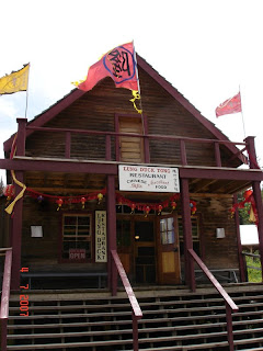
The Town( all the buildings are from the 18th century)

Costumes are also from the same period
St. Saviour's Church. Absolutely beautiful building

Mama and Yaya

Anaesthesia!!

Chinese people came to Barkerville in the 18th century( people from the same province also came to Malaya at that time in seach of Gold and minerals)

Original Barkerville school.

Toothless was fascinated with the scarecrow

Tuesday, July 24, 2007

Why did I do it?

I have been trying to answer that question since I came back. Was it for me? Was it for the kids? I am not really sure.
Before I started the journey, my only experience with camping was the short camping trips I do with my kids, plus staying at the Vidette during Christmas holidays last year.
Apart from that, I was a member of the girl guides.
I must tell that, I hated every bit of girl guides. I was forced to join them because my mother thought I needed the 10 bonus marks you get being a state level guide to pass my SSLC public exam.( She had that much faith in my abilities!!)
First of all, the guides meet on every Friday afternoon and Baker Memorial school where I did my schooling had long lunch break on Fridays(1 to 2.30 pm, because the teachers all had to go for prayer meeting). It is the day when all the girls get to play for a very long time after lunch.
Secondly I had to learn a lot of stuff in English and at the age of 10, I didn't even know to write my own address in English without making a mistake! Imagine attending a meeting on a Friday when all your friends are busy playing and add to that I had to learn oaths and laws in English!
In the first week after joining I had to write girl guide exam. We had to write the guide laws and I couldn't remember the guide laws and instead of writing girl guide is loyal for the 2nd law, I wrote a girl guide is beautiful!!. I still can remember my senior named Lalitha running to the guide leader(Ms.Job) and showing her my answer sheet and both of them laughing their heart out.. Oh how I hated the girl guides!( not to mention all the knots I had to learn, all the badges I had to earn.. all for 10 marks!!)
Any way every summer holidays Amma would pack me off to attend some guiding camps. Though I hated the guides, I enjoyed the camps. Anything that took me out of home was worth every bit of struggle.Even it involved the whole battalion was laughing at you because you were only one who couldn't get morse code right! At the camps I learned how to pitch a tent and basic survival skills.
Almost 30 years ago My father subscribed a magazine called world construction. I couldn't read it because it was in English. But I always liked to see all the pictures of yellow coloured machines. One day my father was reading the magazine and I climbed on his lap, so I too can see the pictures. He was reading about Alaska Highway and showed me the picture of Alaska Highway. He told me how it was built and may be because the way he explained, the word Alaska highway was always in my head. I wanted to see the highway and I told my father that.
He told me "One day you will".
And I knew one day I will..
And I did it, with three kids and the money I saved since I came to Canada by doing catering orders and the experience gained from attending girl guide camps.

Saturday, July 21, 2007

Yeah We did it!

Back home safe and sound.


We travelled a total of 5790km.(Vancouver to Whitehorse(Yukon)and back
Car(see the amount of bugs that committed kamikaze on the bumper??)


Home


will update the blog tomorrow


Friday, June 29, 2007

More Yukon Info

1.The floral emblem of the Yukon is the Fireweed.
2.The official bird is the Raven.
3.The official tree of the Yukon is the sub-alpine fir.
4.The Yukon Territory is large enough to hold the states of California, Arizona, Delaware and West Virginia.
5.The famous Yukon River is 2,200 miles (3,520 km) long. You can canoe 2,050 miles from Whitehorse to the Bering Strait.
6.The central part of Yukon receives 6.5 inches (165 mm) of rain per year, less than Arizona.
7.There are approximately 65,000 moose, 10,000 black bear and 4,500 wolves in the Yukon.
8.The White Pass & Yukon Route is 110.7 miles (178 km) long. Of this, 20.4 miles (32.8 km) are in Alaska; 32.2 miles (51.8 km) in British Columbia, and 58.1 miles (93.5 km) in the Yukon.
9.Whitehorse is the third largest city in Canada by area.
10.The Carcross Desert is the world’s smallest at 642 acres (260 hectares).
11.Whitehorse has the world’s most northern botanical show gardens.
12.Yukon has a population of just over 31,000 people today, almost identical to that of 1900.
13.Of our population base, over 23,000 reside in Whitehorse.
14.This is the home to fourteen First Nations, speaking eight different languages. Gwich'in, Han, Upper Tanana, Northern Tutchone, Southern Tutchone, Tlingit, Tagish and Kaska.
15.Yukon First Nations’ rich culture and history in Yukon dates back as far as the last Ice Age (approx. 50,000 years).
16.Gold is 19 times heavier than water.
17.The Dempster is the only public highway in North America to cross the Arctic Circle.
18.The steamer ‘Seattle’ returned from Dawson City in November 1897 with $800,000 in drafts and securities and 35 lbs. of gold.
19.In 1898 about 25,000 gold-seekers hiked the Chilkoot Trail for the boomtown of Dawson City.
20.A gold nugget was unearthed in the Klondike that weighed over 72 ounces. Its value in 1898 was $1,158 - value today is well over $30,000.
21.One of the first women crossing the Chilkoot Trail in 1897 was Belinda Mulroney from Scranton, PA.
22.The 1,520 mile (2,446 km) Alaska Highway was constructed in eight months and twelve days in 1942.
From http://www.yukoninfo.com

Thursday, June 28, 2007

Yukon Facts

Yukon is one of the three territories of Canada and it lies north of the 60 th parallel. It is bordered to the west by Alaska south by British Columbia,east by North West Territories. Beaufort sea( part of Artic sea) is in the north.

Winter in Yukon is extremely cold and summer is warm. The difference between summer and winter is -40 degrees.

Most of Yukon is covered in Permafrost and it takes 10o years for a tree to grow 10 meters.

The famous Chilkoot pass and Klondike gold trail is in Yukon. During the peak of gold rush, gold diggers found 100 million worth of gold in Yukon.

Alaska highway was built in 1939-45 and was constructed for military purposes.

Mining and tourism are the major industries

Yukon flag

Three colour panel represents the forest, snow and the ocean
Coat of arms in the middle is the cross of St.George that represents the explorers from England, circle represents the fur trade, blue and white wavy lines represents the Yukon river, the red spikes the gold disk represents the mountains and the gold deposits.
Malamute dog sits on top to remind us its loyalty, stamina and strength.

Fireweed surrounds the coat of arm. It is the first plant to appear after a fire and hence the name.

Wednesday, June 27, 2007

Books I will be reading

1. The thief lord by Cornelia Funke
2. Inkheart by Cornelia Funke
3.Inkspell by Cornelia Funke
4.City of flowers by Mary Hoffman
5. City of Stars by Mary Hoffman
6. City of Masks by Mary Hoffman
7. A single Shard by Linda Sue park
8. Keoko by Linda Sue Park
9.Alone on a wide wide sea by Micheal Morpurgo(have been waiting to read this book)

fingers crossed

I am leaving in four days time and I am getting scared. I still haven't packed most of the cloths.
My GPS conked out and I can't afford a new one.
I haven't made any reservation in any camping sites because I have no idea how many kilometers I am going to travel each day.
It was snowing in some parts en route yesterday and I am confused. Should I pack all my winter gear? What if the weather changes and it is hot by the time I reach Whitehorse?
There are more Grizzly bears in Yukon and I have only seen black bears.
I know I should cook food far away from the tent, so the bears won't follow me back to the tent...but .. I am still scared..What if kids bring food to the tent?

I know I shouldn't be worried. I spend a week last winter in a remote lake side at -30 degrees. Without electricity and only the fireplace to keep us warm. We did ice fishing! So this time it should be ok.. Fingers crossed!

Food Supply

I have been told that after Prince George, food availability is limited

So I am taking as much as I can from here

For breakfast
Cereal
Home made pancake mix
I hope to buy sausages/bacon en route

Lunch
Minute rice( quick cooking rice)
Gits Sambar
Luncheon meat
Canned chicken
Canned Tuna
Home made meat masala

Dinner
Pasta
Classico sauce
Cup o noodles
Chapathi
Gits Dosai mix


I have also packed chocolates, trail mixes, 6 gallons of water.
I feel I haven't packed enough food and I am worried.. I hope to find fresh vege and meat en route.. I can't even imagine what would be the case if I don't

Monday, June 25, 2007

Our Gear

BC weather is unpredictable..Today it is the 2 nd day of summer and it snowed on the way to Merrit this morning. So we have to be prepared for a cold spell.
Main gear
5 person 4 season tent
Ground sheet
Air bed
Thermarest pads for the kids
Sleeping bags
Extra blanket(fleece)
Coleman Catalytic heater that uses propane gas
Instead of lanterns I am planning to use solar lights that can charge during the day time.(note: Sun doesn't set at all the next 3 weeks!)
Jackets
Swim suits